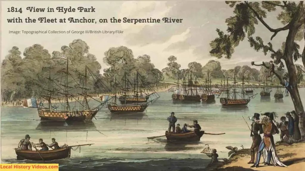
Glimpse history through old images of Pimlico, in the City of Westminster, London, England.
Victorian Poverty
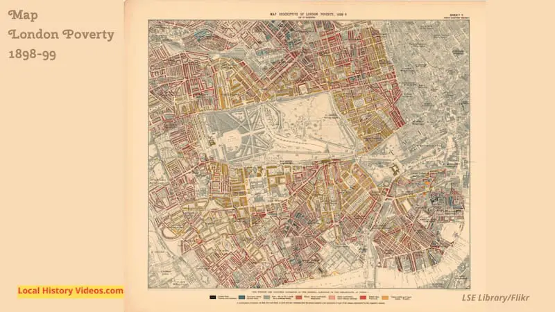
In 1898-99, several maps highlighted average household income levels across London.
Sheet 7, covering the Inner Western District, included Pimlico, Westminster, Brompton, Chelsea, Mayfair, Marylebone, Paddington, Bayswater, Notting Hill, Kensington, Knightsbridge, Pimlico and Belgravia.
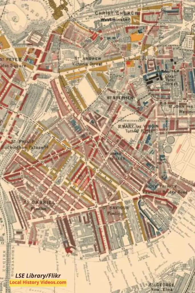
Here’s a closeup of the Pimlico section of the map. It clearly marks out the churches, the railway lines, and the street layout.
Underneath is the key. You’ll notice the yellow highlighted streets of very wealthy households are just a stone’s throw from the huddles of blue highlighted properties housing the very poor in “Casual Want”.
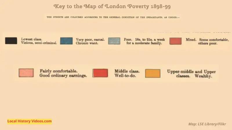
Here is the key to the map.
Notice that the first category is “Lowest Class: Vicious, semi-criminal”. Between that desperate category and the ‘Poor’, whose entire families existed on 18s to 21s a week, were the “Very Poor: Casual, Chronic Want”.
The key brings to mind the imagery of the two emaciated ‘Yellow, meagre, ragged scowling, wolfish’ children called Ignorance and Want, visiting Scrooge in Charles Dickens’ Victorian classic “A Christmas Carol”.
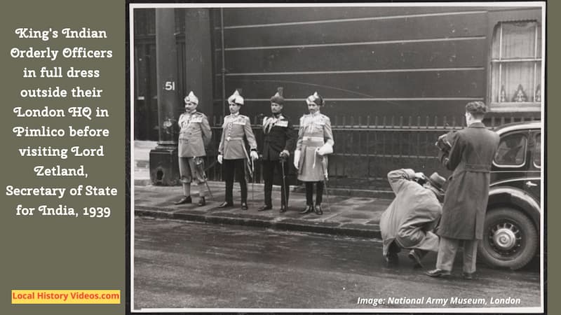
King’s Indian Orderly Officers 1939
In 1903, the Viceroy of India created the posts of King’s Indian Orderly Officers.
Each year, specially selected British and Indian officers and NCOs were appointed for the London season, starting in April and ending in August. They would attend the King at court, official engagements, and ceremonies such as Trooping the Colour.
This photograph shows the 1939 appointed King’s Indian Orderly Officers being photographed outside their London Headquarters in Pimlico. Wearing their official full dress, they departed for a meeting with Lord Zetland, the Secretary of State for India.
The Blitz in Pimlico
While most of Pimlico survived the Lufftwaffe’s bombing raids during the World War II Blitz, some streets were badly affected as the bombs and incendiary deviced reigned down.
Just at the end of 16th April 1941 and into the early hours of 17th April, two parachute mines and three explosive bombs hit Sutherland Terrace SW1, devastating the surrounding area and destroying about thirty homes.
Many people were killed and other had to be dug out of the wreckage. Rescue efforts were hampered by damage to the water mains, the coal gas mains catching fire causing a huge blaze, and the dead telephone lines.
Three of the wardens later received George Medals for continuing to do their jobs despite the exploding bombs and blazing fires putting them at great personal risk.
It took several days for the bodies to be recovered. The final mortuary recovery following this episode was on the afternoon of 20th April 1941, for the feet of Mr Dobson, who had lived at 1 Sutherland Terrace.
On the same night, a parachute mine landed on 39 Lillington Street, located between Charlwood Street and Tachbrook Street. 41 people in the street died, many of them having been sheltering in the basements. The rear of the nearby Cambridge Buildings were also badly damaged.
The bombs returned to Lillington Street on the evening of 19th April 1941, killing another resident.
The windows of Marjorie Kallendar’s hairdressing salon in Warwick Way were blown out, but customers were undeterred and business continued as usual while the replacement glass was patiently awaited.
Lillington Street had a bomb site for several years, before disappearing in the 1960s as the Lillington Gardens housing development got underway.
You can find out more about Pimlico’s experiences of the war on the website West End at War.
Pimlico Mews 1946
This lighthearted short film introduced Dolly the horse, who lives in a Mews stable in Pimlico.
Her owner Tom lives upstairs. He’s been driving London’s Hansom cabs for more than fifty years.
We see him driving his horse drawn cab from the mews to Victoria Station, where he started working before cars had yet appeared.
After dropping off a passenger, Dolly stops for a drink at the cattle trough, while Tom eats his lunch.
As the cab returns home to the mews, we see another man in the road pulling along a large handcart piled high with boxes.
Tom & Dolly (1946) – British Pathé
Pimlico’s 1950 Heating Tower
In 1950, a 140 foot circular glass tower was constructed near to Dolphin Square and the new Pimlico housing development. But it wasn’t a housing, retail or office development, but a revolutionary way to heat local homes.
Powered by the exhaust heat of nearby Battersea Power Station, the steel storage tower, lagged and enclosed in glass, was to supply the central heating and hot water for 10,000 people and save about 10,000 tons of fuel a year.
Needless to say, none of the workmen have any safety equipment at all as they work on the construction of this novel Pimlico structure.
Glass Tower (1950) – British Pathé on YouTube
Devonshire Arms 1968
In 1968, the Alsation dog called Chip Chops was filmed helping his owner Larry Ainsley stack the beer barrels in the cellar of The Devonshire Arms pub in Pimlico.
Pub Dog (1968) – British Pathé on YouTube
A Brief History of Pimlico
This short talk on the history of the area includes vintage pictures and maps, as well as old photos of Pimlico to illustrate how much the area changed in a short span of time.
The name Pimlico was first recorded in the year 1625, describing a settlement on the site of Victoria Square.
In this thumbnail below for the video, you can see the pest-houses at Tothill Fields, drawn by E Dayes in 1796.
A Brief History of Pimlico – Westminster City Council on YouTube
More about London
- Old Images of St. John’s Wood, London
- Old Images of Charing Cross, London
- Old Images of the London Underground Victoria Line
- Old Images of St James’s Park, London
- Old Images of Soho, London
- Old Images of Pimlico, London
- Old Images of Paddington Station, London
- Old Images of Paddington, London
- Old Images of Millbank, London
- Old Images of Mayfair, London
- Old Images of the Chelsea Pensioners, London: Old Age Lived Well
- Old Images of Chelsea Arts Ball
- Old Images of London Streets
- Old Images of London Roads
- Old Images of Marylebone Station
- Old Images of Marylebone, London
- Old Images of the Regent’s Canal, London
- Old Images of Maida Vale, London
- Old Images of Knightsbridge, London
- Old Images of Hyde Park and Hyde Park Corner, London
Discover more locations on our Sitemap of England

