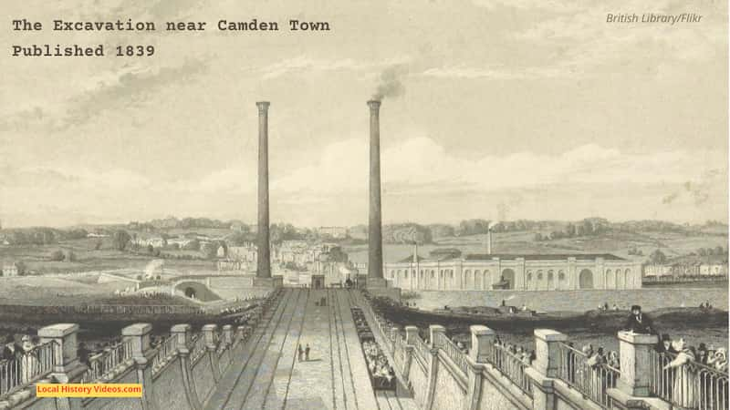
Enjoy a glimpse of history through fascinating old images of Camden, Greater London, England.
Housing in the 1970s
In the 1970s, local residents in some parts of Camden were rehoused, with the vacant premises due for demolition.
In this first item, a report looks at the deliverate damage done to vacant Victorian flats, so that squatters would not move in before demolition.
The residents who had been moved to modern flats now paid increased rent, reportedly up to ten times as much as they had paid in their previous homes.
Meanwhile, a student accommodation body wanted the vacant flats put right again and rented out, since the site had been sitting empty for more than a year.
Don Ryan of the Student Community Housing Group tells us that some of the flats had families living in them when the contractors arrived to make the premises uninhabitable.
Lou MacDonald had lived in the flats for 16 years, and was recovering from a serious operation when the contractors arrived to smash up the flats with pickaxes and sledgehammers.
Councillor John Mills explains that the council couldn’t afford to renovate the Victorian flats to a modern standard, so wanted to demolish them and rebuild. They were ready to start work in February 1974, so moved the tenants to their new homes close by in November 1973 and wrecked the flats to keep them empty before work started. By the DoE was concerned about the scheme on cost grounds, and the soil conditions caused technical difficulties. So the scheme was abandoned.
John Mills says they would not have sent in the wreckers if they had known this scheme would stall, because the council would have preferred people to squat there given the level of housing need in the area.
Meanwhile, the Student Community Housing volunteers did as much of the repair work themselves as they could.
One couple explains that a tenant who refused to move from block 3 was paying 75p a week rent and loved living there for 16 years, but had been moved to new accommodation costing £7 a week.
Camden Council Vandalism (1970-1979) – British Pathé on YouTube
Local Pollution (1972)
Dr W.G. Harding talks about the Environmental work of the local council, including measuring pollution in Camden’s air.
Polluted London | Air pollution | Camden Town | How to measure pollution | The Protectors | 1972 – ThamesTv on YouTube.
Camden High Street (1973)
First shown on 9th August 1973, this short and silent clip from Thames TV includes footage of Camden’s high street and the Camden Theatre, which is now the KOKO music venue.
| 1970s London | 1970s Cars | Something to say | 1973: ThamesTv (YouTube)
Loveridge Road (1983)
On 24th November 1983, Thames News reported on the death of 68-year-old Irene Drury. She had been distressed and lonely after leaving her job and being moved from a busy road to a flat in Loveridge Road, but multiple attempts to get her help from the local social services department had failed. Three weeks after they were called, they visited the flat but couldn’t get an answer. Neighbour Mrs Ann Thomas insisted that the police were called, and they broke in to find the resident had died.
Local councillor Angela Burthill was concerned about budget cuts and a need for improvement to record keeping.
LOVERIDGE ROAD – FLAT – CAMDEN – Thames News on YouTube
Camden Nursery Places (1985)
Thames News reported on 19th July 1985 about a change in the council’s policies for nursery registrations.
CAMDEN NURSERY SCHOOL – Thames News on YouTube
Camden Market (1987)
Filmed on 10th May 1987, six minutes of footage shows people people going about their day at the market, lock, and High Street.
There are good shots of well over a hundred people, with plenty more in the background. Most people are completely unaware of the camera.
Camden Market | 1980s London | Camden Lock | Camden High Street | TN-SL-122-007 – Thames News on YouTube
Camden Town Hall (1987)
A short clip from 9th October 1987 shows Camden Town Hall.
HOMELESS: Camden – Thames News on YouTube
Brief History of Camden
Back in the Mesolithic age, around 7,000 BC, there was a settlement on the area now known as Hampstead Heath.
In 1117, Queen Matilda established the leper hospital of St Giles, which became a general hospital and served the community until the 16th century. Today, St Giles High Street, Charing Cross Road and Shaftesbury Avenue run round the site where st Giles Hospital once stood.
Sometime in the 13th or 14th century, the St Pancras Old Church was built, in what is today known as Pancras Gardens. Construction materials included Roman tiles and bricks. St Pancras was a young Christian martyr killed in Rome in the year 303.
The Great Plague broke out in 1665, close to the parish of St Giles, and quickly spread amongst the community, making one of the worst affected areas of London.
St Giles in the Fields Church was built in 1734, serving what was once one of the more overcrowded and poverty stricken parishes in London. It was probably the third church to have been built on the site.
In 1756, London’s first by-pass toll road was opened, taking travellers and tradesmen east-west from Paddington to Islington without going through the congestion of London. It was originally called the New Road, but then became Euston Road.
Charles Cocks, 1st Baron Somers (1725-1806) owned land immediately north of the new toll road, which had been granted to John Somers (1651-1716), Lord Chancellor and Baron Somers of Evesham, by William III. He saw the opportunity to transform the fields, market gardens and brickworks, into a new development. So in 1784, buildings were constructed at the Polygon, the first residences of Somers Town.
Camden in London was named after Charles Pratt, the first Earl Camden, who started the development of Camden Town in 1791.
1789 was the year the French Revolution started. Many refugees fled to the Somers Town area, to be later joined by refugees from South America and other Spanish-ruled lands.
1706 saw development of a spa at Hampstead Heath, following the discovery of medicinal waters there. The pump room, music and dancing attracted visitors from London and beyond.
In 1820, the Regent’s Canal was opened. Warehouses and factories soon lined the banks of the Regent’s Canal.
The Camden Chapel on Camden Street was consecrated in 1824. It was designed as an imposing neoclassical chapel-of-ease, to attract a wealthier class of worshippers.
Kentish Town saw a large rise in development during the 1840s and 1850s, thanks to its position as a major thoroughfare into London from the north.
To the west of Kentish Town is an area called Gospel Oak. It’s named after an ancient oak tree under which readings from the Gospel took place on spiritually significant days. Unfortunatley, no one knows where exactly the Gospel Oak once stood.
Meanwhile, Hampstead Heath’s attractive views and quiet neighbourhood, all easily reached from the busy streets of London, made it a popular country retreat.
By the end of the 19th century, the the population of Camden Town had grown significantly, boosted by the canal and oter improved transportation systems.
Between the passing of the 1870 Education Act and 1895, Camden Street saw three Board schools open.
In 1877, a Free Library opened in King Street, in the same building as the Working Men’s Club & Institute.
Bayham Place in Camden Town became known for its manufacturers of pianos.
Twenty acres each side of the Regent’s Canal were owned by the wine merchants and gin distillers called Gilbey’s, used for their many warehouses and associated buildings.
Over in Great College Street, Goodall’s had their premises. At the time, they were the world’s largest manufacturers of playing cards.
In the 1890s, soft-drink makers Idris set up premises in Pratt Street.
Camden High Street was home to Oetzmann’s cabinet making factory.
The Aerated Bread Company opened a huge bakery in Camden Road in 1904.
In 1906, the Working Men’s College moved from their premises in Bloomsbury to Crowndale Road in Camden.
The 1960s brought great change to the borough, as housing developments swept away old communities and provided homes fit for the twentieth century.
In April 1965, the metropolitan boroughs of Hampstead, Holborn and St Pancras were abolished, and replaced with the London Borough of Camden.
By 1975, the wharves and warehouses of Camden Lock, next to the Regent’s Canal, were no longer needed for canal transportation. Here Camden Lock Market opened, drawing in locals, tourists and creatives ever since, in an enterprise based around a three story building.
The Buck Street Market and the Stables Market are also popular Camden market locations.
Camden Town’s influence on the music industry is well documented, and the area retains its reputation as a home to artists, musicians, tattoo artists and other creatives.
More Pictures of Old Camden
Old Camden in London, England, enjoyed through historic photos, vintage pictures & archive film. Browse history in these fascinating old images of a bygone era on my Pinterest board at:
https://www.pinterest.co.uk/LocalHistoryVideos/camden-old-photos-pictures
More about Greater London
- Chelsea, London: History in Old ImagesEnjoy a glimpse of history through old images of Chelsea in Greater London, England, UK.
- Wallington, London: History in Old ImagesEnjoy a glimpse of history through old images of Wallington, in Greater London, England, UK.
- Bromley, London: History in Old ImagesEnjoy a glimpse of history through old images of Bromley, in London, England, UK.
- Old Images of Wandsworth, LondonGlimpse history through old images of Wandsworth, London, England, UK.
- Old Images of Southwark, LondonGlimpse history through old images of Southwark, London, England.
- Old Images of Richmond upon Thames, LondonGlimpse history through old images of Richmond upon Thames, London, England, UK.
- Old Images of Purley, LondonGlimpse history through old images of Purley, London, England, UK.
- Old Images of Merton, LondonGlimpse history through old images of Merton, London.
- Old Images of Lewisham, Southeast LondonGlimpse history through old images of Lewisham, in Southeast London, England.
- Old Images of Lambeth, LondonEnjoy a glimpse of history through old images of Lambeth, London, England.

